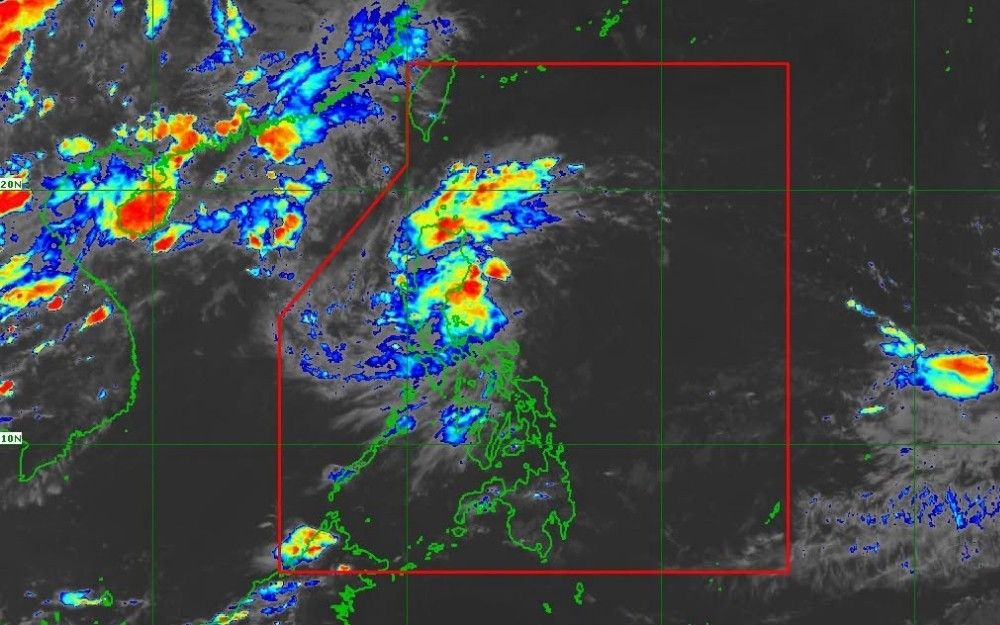
Tropical Depression Luis, in combination with the prevailing southwest monsoon (habagat), is expected to produce heavy rainfall over Metro Manila and multiple provinces across Luzon through Wednesday, according to the Philippine Atmospheric, Geophysical and Astronomical Services Administration (PAGASA).
In a bulletin issued Sunday, PAGASA reported that accumulated rainfall of 100 to 200 millimeters is anticipated in Zambales, Bataan, and Occidental Mindoro during the forecast period.
Current Status of Tropical Depression Luis
As of 4:00 p.m. August 2, Sunday, the center of Luis was estimated at 285 kilometers east of Baler, Aurora, having moved from a position 400 kilometers east of Infanta, Quezon, recorded at 10:00 a.m. the same day.
The system maintained maximum sustained winds of 55 kilometers per hour near its center, with gustiness reaching up to 70 kph. Luis was tracked moving northwestward at 15 kph, with strong winds extending outward up to 160 kilometers from its center.
Tropical Cyclone Wind Signal No. 1 remained in effect over the Polillo Islands, Camarines Norte, the northern portion of Camarines Sur, and the northern portion of Catanduanes.
In Camarines Sur, the signal applied to the municipalities of Caramoan, Garchitorena, Lagonoy, Tinambac, and Siruma. In Catanduanes, it covered Pandan, Caramoran, Bagamanoc, Panganiban, and Viga.
PAGASA indicated that these areas may experience winds of 39 to 61 kph, with minimal to minor impacts to life and property. The agency noted that Signal No. 2 could be raised depending on the system’s progression.
Rainfall Forecast
PAGASA outlined the following rainfall projections:
– Sunday through Monday afternoon: 50 to 100 mm over Pangasinan, Cagayan, Isabela, Quirino, Zambales, Tarlac, Nueva Ecija, Bulacan, Aurora, and Quezon.
– Monday afternoon through Tuesday afternoon: 50 to 100 mm over La Union, Pangasinan, Benguet, Isabela, Quirino, Aurora, Nueva Ecija, Bulacan, Tarlac, Pampanga, Zambales, Bataan, Metro Manila, Cavite, Batangas, and Rizal. The southwest monsoon is also expected to deliver 50 to 100 mm to Occidental Mindoro during this period.
– Tuesday afternoon through Wednesday afternoon: 100 to 200 mm over Zambales, Bataan, and Occidental Mindoro, attributed primarily to the southwest monsoon. An additional 50 to 100 mm may fall over La Union, Pangasinan, Benguet, Tarlac, Pampanga, Bulacan, Metro Manila, Cavite, Rizal, Batangas, and Antique.
PAGASA noted that rainfall totals may be higher in mountainous and elevated terrain, and that impacts could be amplified in areas that have already received substantial precipitation in preceding days.
Projected Track and Intensity
Luis is forecast to continue on a generally northwestward trajectory over the next 12 hours before recurving east-northeastward for the remainder of the forecast period. The cyclone’s center is expected to remain over the Philippine Sea.
PAGASA cautioned, however, that a westward deviation in track could bring the system closer to or over Northern or Central Luzon, and that adjustments within the forecast confidence cone remain possible.
The depression may intensify into a tropical storm within 24 hours while traversing waters east of Central Luzon. It is expected to maintain tropical storm status only briefly before weakening as it turns east-northeastward. By Wednesday, August 5, Luis may degrade into a remnant low-pressure area before being absorbed into the broader circulation of Typhoon Dolphin.
Wind and Sea Conditions
The combined influence of the southwest monsoon and Luis’ outer circulation is expected to generate strong to gale-force gusts, particularly over exposed coastal and upland areas.
On Sunday, gusty conditions were anticipated over Marinduque, Occidental Mindoro, Oriental Mindoro, Romblon, Masbate, Sorsogon, the Caluya Islands, Northern Samar, Samar, Biliran, Siquijor, Southern Leyte, Camiguin, and the Dinagat Islands.
On Monday and Tuesday, strong to gale-force gusts may affect the majority of Luzon and the Visayas, as well as Lanao del Norte, Misamis Occidental, Camiguin, Surigao del Norte, the Dinagat Islands, Sarangani, Davao Occidental, and Davao Oriental.
Regarding sea conditions, moderate to rough seas with wave heights of up to 2.5 meters may affect the eastern seaboard of Davao Oriental. Waves of up to 2 meters are anticipated along the seaboards of Isabela, Surigao del Sur, and Davao Occidental; the eastern seaboards of Cagayan, Catanduanes, and Northern Samar; the northern seaboards of Aurora, Camarines Norte, Camarines Sur, and Catanduanes; and the remaining seaboard of Davao Oriental.
PAGASA advised operators of motorbancas and similarly sized vessels to exercise caution and, where feasible, to refrain from sailing under the forecast conditions /Clarence Pacaña